The Airport Road Connection Feasibility Study is evaluating whether Arapahoe Road can be extended from its current endpoint at County Line Road east and south to connect with Airport Road and Colorado Highway 7. The study is reviewing key constraints in the area, including Coal Creek, the Erie Municipal Airport and the Lafayette Water Treatment Plant, to determine whether a roadway corridor could be built and maintained in a practical, cost-effective way.

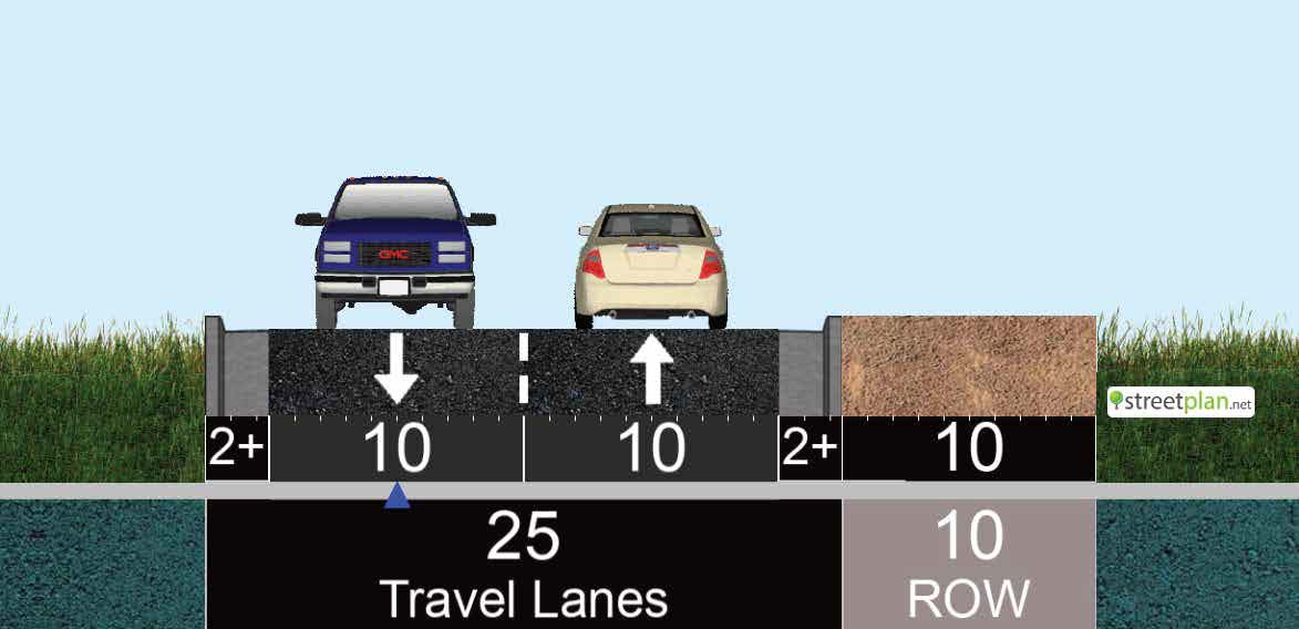
This effort is intended to address existing traffic conditions and projected growth in the study area. Increasing volumes on Arapahoe Road, Colorado Highway 7 and Vista Parkway have created a need to evaluate options for added east-west capacity and a more direct connection between the Arapahoe Road and County Line Road intersection and the Airport Road and Colorado Highway 7 intersection.

The project team is analyzing study-area constraints, current travel patterns and forecasted traffic growth to identify potential alternatives and narrow them to roadway alignments that could be viable for future implementation.

An open house will be held at the Erie Municipal Airport on Wednesday, Feb. 25, from 5 to 7 p.m. Residents are encouraged to attend to learn more about the study and share input with the project team.

Step 1: Alternative Route Preference (and recommendations)
Step 2: Amenities

Whichever route option is selected, the available right-of-way in this area limits how many amenities can be built alongside the road. Based on those constraints, please choose the amenity options below that matter most to you so the project team can prioritize what should fit within the space available.

Connection Types (option 1)

Amenity Options

Click below to view visual representations of the available amenity options for this stretch of roadway.

Choose Your Top Amenity

Pick the amenity that you think is most important to include in the 10ft of Right-of-Way along the road in this area.
Amenity options for the 10ft of available right-of-way